Wednesday, July 31, 2019

SUMMER 2019, PART 2-C: CALENDAS

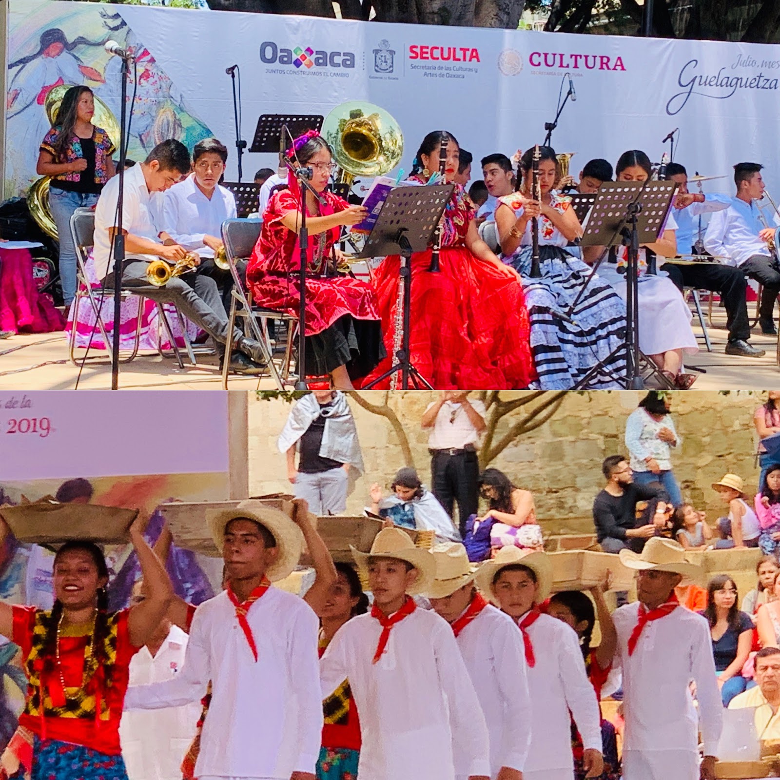
A calenda is basically a parade filled with laughter, dance, music, and displays of people's cultures. 

The word calenda comes from the Greek and in a few words it is a calling to come together and celebrate one's religious practices. In Oaxaca, however, a calenda goes beyond religion for it also celebrates Indigenous practices, traditions and culture. 
The state of Oaxaca is divided into seven geographical areas and each area has different Indigenous communities. During the Guelaguetza Festival, the different communities come to Oaxaca to participate in exhibitions, dances, music concerts, food expositions, drinking (mainly mezcal) expositions, and arts and crafts expositions. 

While the Guelaguetza Festival happens during the entire month of July, it is during the last two weeks of the month when the festivities intensify. This has to do with two main factors: 1) Lunes de cerro (Mondays of the Hill) and 2) Las Candelas de las delegaciones (The Delegations' Candelas). I will talk about Mondays of the Hill in another post. This post is all about the calendas.

As part of the celebrations, each region is allowed to bring a minimum of one delegation and maximum of three delegations per region. The delegation represents a specific community from one of the seven regions of the state. Some delegations are composed of two or more different communities within a region, depending on the size of the community and economic factors.
During the last two weeks of Guelaguetza Festival, these delegations gather at a specific time and place and walk down the streets from "Point A to point B." Point A is their gathering area and Point B is the Oaxaca's city's main plaza: El Zócalo.

Each delegation has an estandarte (banner) which lets people know to what communit(ies) they belong and from what region. And as they walk down the streets, they dance, yell the name of their community and region, throw random gifts to onlookers, and share mezcal shots with many.

In short, the whole calenda is a celebration of culture, religion, art, dance, music, and Indigenous practices. Best experience ever!!!
Here's a short video showing one the calendas:
Next: THE MUXE!

Tuesday, July 30, 2019

SUMMER 2019, PART 2-B: HIERVE EL AGUA & MITLA

As a captal, Oaxaca is the main hub for taking tours around the entire state. One of the tours we took was to Hierve el Agua and Mitla.


Hierve el agua (Water that Boils) is located about 60 km (37 miles) east of the Oaxaca. Par of the way there is through a brand new toll highway and part is through a very winding unpaved narrow road. It is frightening to see vehicles driving through such unpaved road because on the way to Hierve el agua, the passenger side sees a cliff (about 30 meters-98 feet) down. and on the way back the passenger side sees that.


Once in Hierve el agua though, it is a beautiful sight. With thermal waters springing from the mountain and creating natural pools for people to swim while enjoying the natural beauty of the entire mountains and valley.

After Hierve el agua, we headed to MITLA, the land of the underworld, dedicated to the God Mitlantecutli and the most important place for the Zapotec people.

Mitla is small but its importance to the Indigenous people of Oaxaca, specially during Day of the Dead, is indescribable.

During our visits to both Hierve el agua and Mitla, we stopped in three other places. A place where Indigenous people hand make zarapes and many other artifacts made of wool, a mezcal distillery, and a town with the longest living tree.

This image aboves hows the place where people dye the wool with all natural resources. It was amazing to see how they use natural material from the area to create such beautiful colors.

The image above shows a grinder where the already cooked and marinated maguey is thrown so the giant rock, pulled by a donkey, can grind the cooked mezcal in order to extract the juice, which will be treated, fermented, and left in barrels for different periods of time to create the different elixirs of the Gods: Mezcal.

The image above is from the town of TULE and the tree you see in the background is the longest living tree, with more than 2000 years in existence. Information available on the site states that the trunk is about 42 meters (137 ft) in diameter or circumference and 35 meters (116 ft) high.

Although not visible in this image, the trunk shows images of animals such as jaguars and elephants, horses, and more... for this reason, El árbol de Tule (The Tree of Tule) is also known as El árbol de la vida (The Tree of Life), which is the inspiration for the many variations of the "tree of life sculptures."

An example of a tree of life sculpture.

NEXT: CALENDAS!

Monday, July 29, 2019

SUMMER 2019, PART 2-A: OAXACA AND THE GUELAGUETZA FESTIVAL

After two weeks of intense heat and humidity in #Merida #Yucatan, Miguel and I finally arrive in #OAXACA just in time for the #GUELAGUETZA. The city received us with great weather and no humidity and lots and lots of music.

Here we are, at the airport, waiting for our luggage and taking opportunity of the giant posters on the airport's wall.
We are tired, our journey from Merida to Oaxaca started at 4AM. It is now four hours later.

Once we settled in our apartment, we found a place to eat.
Cheap food and made to order. I love going to street food markets.

After our early/late lunch we walked around town. Although we knew Oaxaca is a colorful city and its Guelaguetza Festival had began two days before we arrived, we had no idea what Oaxaca had in store for us.


Basically this happens Monday - Friday for the next two weeks:

Four different cultural presentations in four different spots of the city's downtown (Dance, Music, Theatre), starting at Noon and ending at six p. m. take place everyday.


Also, every day at 4 PM, different delegations (representing a Oaxaca Region/community) gather somewhere in the downtown area (mainly Santo Domingo area) where they dance and drink mezcal. Then, around 5 or so, the delegations walk down to El Zócalo. So while you may be following one delegation, on your way you may run into another delegation so those join in and so on until everyone converge at the main plaza. By the way, each delegation has its own traditional music band, playing music from the region they are representing. Some songs are the same for they are the traditional Guelaguetza songs, so while walking or watching the delegations go by (the Calenda), you may hear a lot of different type of music play by the different bands. The members of the delegations usually carry baskets with gifts that they throw to the onlookers, while others members give free mezcal shots as they pass by, if you carry your own small shot glass, for sure you will get mezcal from delegation members.

Besides these activities, there are also the expositions going on at the convention center: La Feria del Mezcal (Mezcal Fair), La Feria de las Artesanias (Arts and Crafts Fair), La Feria Infantil (Children's Fair), and La Feria de los Antojitos (Traditional Food Fair). These are open from 10 AM to 10 PM.

These expos are so good that so far, we have gone twice in one week.

Starting around 8PM, the afternoon delegations meet again and throw a big celebration in the zocalo (this goes until midnight), while in other parts of downtown there are free music concerts and dance parties.

There is also the paid music concerts given by famous music groups and artists, or the many paid cultural events such as DONAJI: THE LEGEND, the Official CALENDAS (happening only on Saturdays) and of course the main event LA GUELAGUETZA, which only happens FOUR TIMES, twice on the last two MONDAYS of July.


And let's not forget the many events hosted by different restaurants, the many street performers, and "private parties" taking place on the streets. (We witness a wedding taking place on the street and while the invited guest were inside eating, the dance took place on the street so everyone could enoy it.)

The point is that M-T from about 10AM to about 2 AM and Fridays and Saturday from 10 AM to 5 PM, Oaxaca parties like no other city I have ever seen.

NEXT: HIERVE EL AGUA & MITLA!

Sunday, July 28, 2019

SUMMER 2019, PART 1-I: MAYAPÁN & KANKIRIXCHE

Our adventures in Yucatan, Mexico ended with a visit to one more archeological site and one more cenote: Mayapan and Cenote Kankirixche.

Mayapán is known for being the "Bandera de los Mayas" (Flag of the Maya) and it is considered the last main Maya Capital. This city hosted "La Liga de Mayapán" (The league of Mayapán) where the powerful political leaders of both Uxmal area and Chichén-Itza area came together for peace talks. And every year, the league would come together to celebrate their alliance in Mayapán.

Mayapán's main attraction is a pyramid similar to El Castillo in Chichén-Itzá, except much smaller. It is also known as "El Castillo." And unlike the one in Chichén-Itzá, we were allowed to climb it.

Mayapán covers 42 km2, which is about 10, 378 acres. In this area, one can find about 4,000 different structures. It has civic, administrative, and religious buildings.

Many residences, including government official houses, which have long corridors, altars, and several rooms and columns.
There are also buildings with small altars for "lesser deities."

One can also find observatories, and sanctuaries.
After we visited Mayapán, it was time to take a swim in a cenote. There are so many cenotes around Mayapán, some who have been turned into tourist attractions, others who are just happened to be visited by people who dare to find it.

We are such people and it took us about 30 minutes, getting lost, and driving in a very narrow mud road to find what was promised by a local Maya as breathtaking cenote called Kankirixche, known to mostly local people. AND IT WAS!

 At first sight you wouldn't know there is a cenote here. See, the tree, well, it marks the spot where the water whole is located.
 Once you reach the tree you can see a huge whole in the ground.


From the inside it looks like this:

The water is cool, very blue and very clear. The deeper you go, the darker the water gets. The image above was taking from the deeper side of the cenote. To my immediate right it gets deeper and if one dares, one can swim down and go under a cave. BUT what would anyone want to swim deeper and go under a dark underwater cave?

Here's a video, which I took while swimming so once in a while the camera is turned the wrong way:


Next: OAXACA during its biggest festival: LA GUELAGUETZA!

Saturday, July 27, 2019

SUMMER 2019, PART 1-H: IZAMAL

Thirty minutes east of Merida Izamal, the "yellow city" is found. It has three great attractions:

1. All the houses in Izamal are painted yellow, hence the "yellow city."
The image above is a combination of two shots take from my car.

2. Izamá has a monastery with the 2nd larges patio (second only to the Vatican). More about it later.

It's a eyesore to see such building. It is just immense. The monastery is now out of commission, it simply houses a chapel, a museum, and a small arts & crafts store.

3. The biggest pyramid (by square footage) is found is this town and it is known as Kinich Kak Moo, dedicated to the one of the most important deities of the area: Kinich Kakmo, which means the fire macaw with the sun face."

This pyramid is hidden underground and also seen overground. It is so vast that it is bigger than any other pyramid in Mexico (when it comes to square footage).

The image above is the beginning of the pyramid steps (face 1). It is a long way up.

Once you reach the "top" you find a large field, which you still need to cross in order to reach the beginning of the top of the pyramid.

Above, you can see Miguel climbing the pyramid. I am climbing the pyramid too but I am taking my time because I'm me.

Despite the fact that the pyramid was destroyed to build other houses and churches, this pyramid can be seen from all around the town.

Here's a video taken from the top of the pyramid:


Now for my #selfdecolonizing moment:

The reason why the monastery has a very long patio is because when the colonizers (yes, that is what they are) arrived in Izamal they decided to destroy the pyramids, which were temples to the Maya Gods. So, as part of their colonization, they build Christian churches on top of the pyramids.

In the case of monastery, they have to cover the entire square footage of the pyramid and use part of the pyramid to build the church as you will see in the image below.

The front of the monastery looks pretty, and the back shows the stones from the pyramid that were repurpose to build such monastery. If you look at the combined image of the monastery (posted earlier), you will see that the floor and the steps leading to the main entrance are all made of stone, stone that came from the pyramids. So, seeing this makes me angry and sad. It happened and now we just have to accept it.... but I can still be angry about it.

NEXT: MAYAPAN & KANKIRIXCHE!

Friday, July 26, 2019

SUMMER 2019, PART 1-G: DZIBILCHALTUN

Once we were back from Playa del Carmen, we had just three more days to enjoy Merida and Yucatan in general.

About 30 minutes from our rental house, which is the best house we have ever rented, there is a small, but very important archeological site, DZIBILCHALTUN. The name means "place where writing is found on flat rocks."

The site is beautiful, very green, with lots of trees and it even has its own cenote or rather ojo de agua (water whole).

The main attraction seems to be cenote, for everyone can go swimming in it, and we did. To me, however, the main attraction is the "House of the Seven Dolls," name because when excavated, they found seven small female figurines.

But the whole site is just breathtaking. Looking around you hear the birds sing (lots of them by the way), you see iguanas, you see strange trees with strange flowers, and of course MOSQUITOS.

And because humidity is at 1000%, you look like this in front of one of the most beautiful "ojos de agua" I've seen.

From afar, the water looks so crystal clear blue, and once in it, it turns green... what sort of magic is at work here?
 Fresh refreshing water that calms the day heat.

The most spectacular event about this site happens in March and December, where the sun comes up and shines through the house.... I mean, the house was built in a way that is perfectly aligned with the sunrise.

The Maya people did not do things by chance. Everything was calculated!

NEXT: IZAMAL!

SUMMER 2019, PART 1-F: PLAYA DEL CARMEN & XPLOR

Playa del Carmen is three hours from Merida, Yucatan and in the state of Quintana Roo. Cancun is located in Quintana Roo, and so are some of the most beautiful beaches in Mexico, such as Cozumel and Playa del Carmen.

We did not drive to Playa del Carmen to go to Playa del Carmen. We actually stayed in Playa del Carmen because we were going to XPLOR, a water/zip line/underground rivers amusement park and the closest city to stay was Playa del Carmen. So, when in Rome...

Since we were in town, we visited the Playa del Carmen' beaches just to find out they were closed or semi-open because of an algae issue which has turned the clear green, turquoise waters into brown non-clear waters. NO ONE WAS SWIMMING!

You can see the algae pile up at shore but most disappointed, you can see the see, which is not clear, nor green, nor turquoise. But as I said, we were there because our adventure to XPLOR. Since we couldn't swim and the heat was sort of unbearable, we decided to play tourist, walk through "Quinta Avenida" the biggest outside tourist mall I have ever seen, and then, dip our bodies in the rooftop pool of our small rental apartment.

 This photo was taking at an intersection while we walk Quinta Avenida. NO FILTERS.. the sky is just gorgeous.

This photo was taken after we got to our apartment and decided to take advantage of the rooftop pool. That is the moon, shining so beautiful in the background!

After our swim, we went to bed and the next day we went to XPLOR, which was an entire day of fun, fun, and more fun. Here are some pictures of that adventure:

Here's Miguel getting ready to get soaking wet as he arrives at the end of the zip line... he is heading to a waterfall as he lands into the pool of water.

Here is me, heading to that tower that you can see towards the right. And yes, the excitement of going down and over the trees is exhilarating. 

Here's the two of us swimming in an underground river.

Here's the two of us driving an amphibian vehicle through the jungle, which was so scary because we have to drive through hanging bridges, caves, and water lakes... it was exciting though.

Here we are walking through a hanging bridge (those things move so much), heading to the tallest towers in the zip line circuit. 

Here is one more of us in the underground river.... because it was Miguel's favorite activity

And last but not least, one more image of us... the last picture of the day after we took shower and were on our way out.
XPLOR was, indeed, an incredible park. One we want to do again in the future (I needs to lose weight, 'cause it was hard) and one we want to combine with the other park, XCARET.

NEXT: DZIBILCHALTUN (Say it three times with me, ready?)